Tikal
Tikal
Tikal, in the heart of Guatemala's Petén region, is one of Central America's largest Mayan sites. Soaring temples, tropical wildlife, and dynastic stelae compose a rich visit, accessible from Belize.
Tikal is one of Central America's largest Mayan sites, located in northern Guatemala, in the heart of Petén, near the Belizean border. Its pyramid temples rise above the tropical canopy, surrounded by a forest inhabited by howler monkeys, toucans, and coatis. The site spans more than 570 km² of UNESCO-listed national park, with a dense archaeological core around the Great Plaza.
Practical Information at a Glance
- Admission: paid entry (national park fee; separate rate for non-Guatemalan residents)
- Recommended duration: a full day minimum; two days to explore remote groups
- Access: from Flores (Guatemala), approximately 65 km by road; shuttles and shared taxis available
- Attire: light clothing, closed-toe non-slip shoes (wet ground and roots)
- Rules: temple climbing prohibited on most structures; Temple IV remains accessible
- Accessibility: limited — dirt paths, significant elevation changes
What You'll See
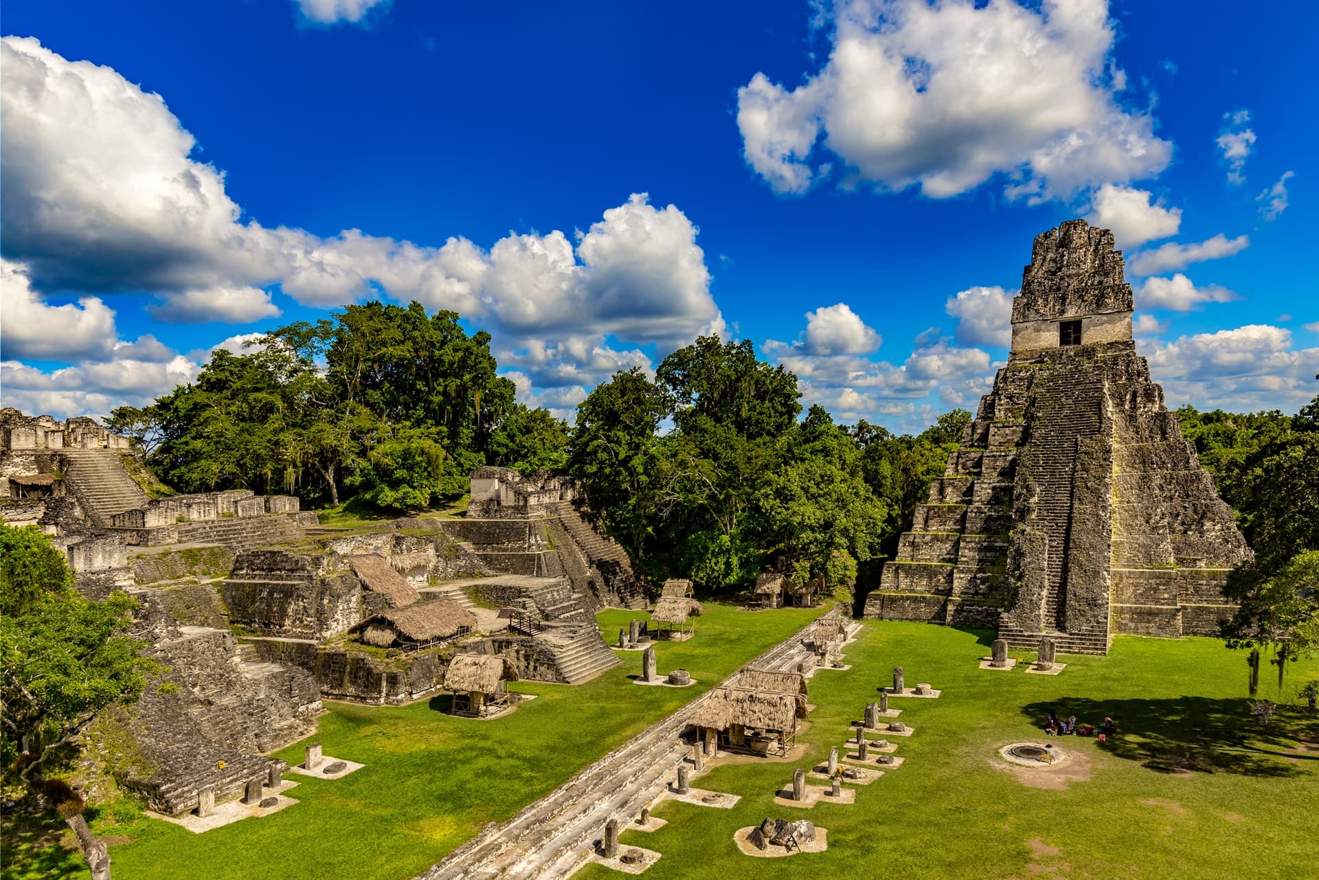
The site encompasses thousands of structures: temples, palaces, ball courts, altars, and carved stelae. The Great Plaza (Gran Plaza) concentrates the most iconic monuments. The surrounding forest is integral to the experience—wildlife is omnipresent and audible from dawn.
History and Context
Tikal was occupied as early as the 9th century BCE. The city reached its peak between 200 and 900 CE, during the Maya Classic Period. At its height, it housed up to 100,000 inhabitants. Rival to Calakmul, it was also allied with Teotihuacan. Its decline began around the 10th century, before rediscovery by explorers in the 19th century. UNESCO inscribed it as a World Heritage Site in 1979.
Highlights of the Visit
Temple I — Temple of the Great Jaguar
Rising approximately 47 meters, this funerary temple dominates the Great Plaza. It was built for King Jasaw Chan K'awiil I, who died around 734 CE. Its silhouette is Tikal's iconic symbol.
Temple IV — The Canopy Viewpoint
The site's tallest temple (approximately 65 meters). Wooden stairs allow ascent to the summit, where the ridges of other temples emerge above the forest. The view is particularly striking at dawn.
The Great Plaza
Central space surrounded by Temples I and II, the North Acropolis, and the Central Acropolis. Aligned stelae and altars narrate royal dynasties in carved glyphs.
The North Acropolis
A funerary complex layered over centuries of construction. Excavations have revealed stucco masks and royal tombs.
Park Wildlife
Howler monkeys, spider monkeys, keel-billed toucans, scarlet macaws, coatis, and ocelots inhabit the forest. Dawn and dusk are optimal for wildlife viewing.
Photography Tips
- Best light: sunrise from Temple IV — arrive before official opening with an authorized guide for dawn tours
- Angles: photograph the Great Plaza from the North Acropolis steps to frame Temples I and II facing each other
- Restrictions: drones require special park authorization; flash prohibited in excavation areas
- Wildlife: telephoto lens recommended for birds in the canopy
Location and Access
Tikal sits in Petén department, northern Guatemala, approximately 65 km from Flores. The road is paved. Daily shuttles depart from Flores and Santa Elena. From Belize, the Melchor de Mencos border crossing is closest; cross-border transfers are organized from San Ignacio, Belize. Lodges operate within the park for overnight stays.
Nearby
- Xunantunich — Belizean Mayan site with El Castillo pyramid, accessible from San Ignacio.
- Caracol — major Mayan city in Belize, historical rival of Tikal, in the Maya Mountains.
- San Ignacio — Belizean hub town for excursions to Tikal and Petén sites.
- Lamanai — Belizean Mayan site on New River Lagoon, accessible by boat.
Frequently asked questions
Tikal is located in Guatemala, in Petén department. However, it is heavily visited from Belize, particularly from San Ignacio, due to its proximity to the border.
The dry season (November to April) facilitates access and movement on dirt trails. During the rainy season, the forest is greener and crowds are smaller, but paths can be slippery.
Climbing is prohibited on most structures for conservation reasons. Temple IV has wooden stairs allowing legal summit access.
A full day covers the main monuments. Two days allow exploration of outlying groups (Group G, Temple VI, Mundo Perdido) and sunrise viewing from Temple IV.
A guide is not mandatory but strongly recommended. Park officials know glyph history, animal species, and access to less-trafficked areas.
Yes. Day excursions from San Ignacio, Belize include border crossing and Tikal visit. Multi-day combinations with Xunantunich or Caracol are also possible.
Interested in this visit?
We can include it in your personalised itinerary.